
In this report-back, some news of new maps and downloads, more lekker inputs and a great session with Alex Basson, ‘Die Bergman’.
PLUS A VERY IMPORTANT REQUEST! [see below]
First, your email responses.
Mike Scott wrote that pic 35 in Book One is The Anvil. Thanks Mike – indeed confirmed by Alex Basson. Pic 127 that we thought might be The Anvil is in fact the Turret of Turret Ridge, on the western side of Skerpioensberg.
 |
| Left: The Anvil :: Right: The Turret |
Mike also confirmed that 153 is the MCSA’s water-supply at Bakmakersfontein, and that Disa Pool is indeed incorrectly shown on the ‘official’ maps. He suggests that the prominent pool that is on the present maps be named ‘Bakleikraal Pool’ – any objections?
More on Mike Scott vs Alex Basson below!
 |
| Bakleikraal Pool? |
Johann Lanz sent further comment on the Knobless Robot [pic 50] – thanks, Johann.
Charles Merry sent the true coords for the Sandfontein Arch, taken by Ezan Wilson. Great, I think our map will be the first that positions the arch correctly.
Rudolf Andrag sent news of the Cederberg Management plan and the public meeting in Clanwilliam for the 31st Jan – you can download the relevant doc at http://www.capenature.co.za/eco-tourism.htm?sm[p1][category]=720&sm[p1][persistent]=1
– scroll down to Download: CNRC_PAMP_FINAL PARTICIPATION_12DEC2011 _1_.pdf
Be warned, it’s a large download.
Nicky Lombard sent useful info re the Maltese Cross path, and a request that GPS coords for path junctions be made available as a download, so that users can import them to a GPS reader. Great suggestion – we’ll investigate.
Finally, before launching into Alex Basson’s superb info, I wrote to Peter Hart indicating that we’d like to collect place names, where available, from the Heuningvlei/Wupperthal/Eselbank locals – names like ‘Oompie’ that don’t appear on existing maps, yet which will be lost if they are not recorded. Peter has suggested Abraham Ockhuis, Izak Koopman and Abraham Jantjies of Heuningvlei and Ben Zimri of Brugkraal. Any other suggestions, anyone?
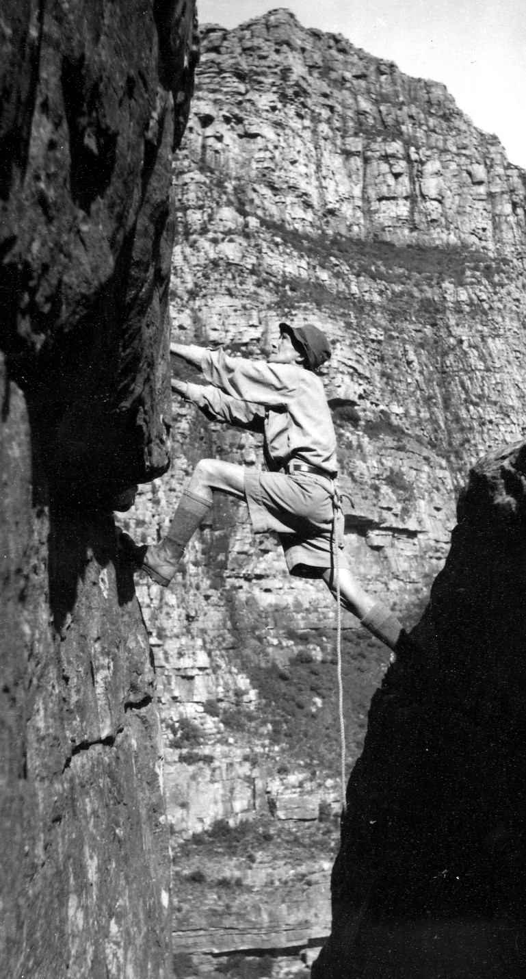 |
| TP Stokoe, aged 84, on the Spring Stepover |
I owe Alex an apology – he was, of course, a teacher at SACS, not Rondebosch – my mistake. Alex spent a very generous morning with us, on the very hottest of those hot January days. He’s a gold-mine of information, the great mass of it gleaned from the oldest Cederbergers, the forest workers whom he accompanied in the 1950s. They and their fathers and grandfathers knew the mountains intimately for decades before the ‘Peak Baggers’, the Engelse mense who in the early days congregated at Kromrivier to engage in the strange pursuits of mountain climbing and hiking. Just as we had reported from the letters of TP Stokoe [included in our biography of that fascinating old botanical mountaineer], in the pre-war years you got to the Cederberg by taking the train to Eendekuil, then waiting from midnight until 6 am for the bus to Kriedouwkrans. From Kriedouwkrans, near the present N7, you hiked with donkeys into the mountains ... think of that next time you rip over Nieuwoudt’s Pass in your 4 x 4. Alex knew Stokoe, and was with him when Stokoe re-climbed the Spring Stepover on Table Mountain, at the age of 84 ...
I have two tightly-scrawled pages of my notes from Alex’s visit, too much info to detail here but much of it will certainly greatly enrich our map. Of interest, though, because we have other inputs on these, are:
* Vogelgesangvallei: This is in fact NOT as Ralph Taylor has it, the valley below Engelsmanskloof – the Trig map is actually correct! The ‘vallei’ is the ‘vlei’ or extensive seepage zone on the path down to Kleinvlei, with its prominent and beautiful waterfall. This makes much more sense to me: ons Engelsmense tend to forget that the Afrikaans geographic reference vallei usually means vlei or marsh. I also doubt the presence of too many singing birds in those harsh high-mountain areas.
 |
| The real Vogelgesangvallei; the waterfall is to the right |
* Basson se Klip: Here I have a problem. It would seem very churlish and inappropriate not to show Alex’s ‘klip’ on the map, but Basson se Klip is actually a cave with rock art, so we cannot show it in its precise position. In the old days it had a wooden floor, and the entrance was walled off with wood and a proper door – rather like the Makkedaat Cave in Baviaanskloof, and considerably older than the latter. Mike Scott, Alex identifies the ‘klip’ in your pic as Vanzylsklip – without a doubt! Interestingly, Ralph Taylor has this correct on his map. There is an old footpath from here down to Agter-Warmhoek; we’ll show it on the new map as a ‘way to go’.
 |
| Vanzylsklip: we think that Alex should know! |
A VERY IMPORTANT REQUEST ...
It has been suggested that we include on the map [or provide online as free downloads] enlarged insets of:—
[a] trail-heads – how to find the starting point of routes into the Cederberg, and
[b] High peaks – safe, non-climbing routes that might be cairned or even have footpaths. I would welcome comment on this, and if anyone has GPS tracks that they are prepared to share [with acknowledgment, of course] for the following, I would be very grateful:
* Routes up the Krakadouw peaks
* Skerpioensberg
* Sneeukop
* Tafelberg
* the northern ridge-route up Sneeuberg, over Sterrebosbank
* any in the Apollo Peak area and the MCSA area to the south of Breekkrans.
I am NOT necessarily looking for ‘formal’ paths, only ‘ways to go’ that might improve the safety-value of the map.
And to end off, the formal stuff ...
Mapping News
NEW Waterproof maps – in response to public demand we’ve printed waterproof editions of our Cederberg [touring], Swartberg and Wild Coast maps. At the mo these are only available online – see www.slingsbymaps.com
NEW free downloads – we’ve moved the freebie Algeria maplet to a new page which you can access from the Free Stuff button on the Hike the Cederberg page. There’s now also a freebie maplet of HEUNINGVLEI, as an example of the ‘trail-head’ insets we’re hoping to include on the map. We’ll shortly also have a freebie of the route of the Cederberg Heritage Route’s new Gabriel’s Pass Trail.

Mapping the hiking map proceeds apace; we have almost finished the digitizing for side one, and I am hoping that by the end of Feb I might have snapshots of bits of the map up on this blog for your comment.
Info already in:
Already acknowledged: Rudolf Andrag, Quinton Martins, Ronnie Hazell, Charles Merry, Wim Morris, Alex Basson, Graham Bellairs, Julyan Symons, Galeo Saintz, Paul la Grange, Laurence Elton, Mike Scott, Peter Hart, Justin Lawson, David Donald, Johann Lanz, Cisca Nieuwoudt, Hendrico Burger
All comments more than welcome!
Kaartman, 21-01-2012