Sad to have to report the loss of two of the Cederberg’s sincerest devotees. Moritz Connrad would have been known to many readers of this blog; he and Andrea contributed valuable insights and information to the new hiking map, even though their farm, Enjolife, fell outside the mapped area. Moritz died tragically in a light aircraft accident a week ago; he leaves his wife and two young children and a host of grieving friends. At times like these we face our hopelessness and helplessness – we want so much to do something, say something, put this awful thing to rights. We are devastated by the suddenness and the harshness of Moritz’s passing; our thoughts, sympathy and condolences go to Andrea and the children.
Angus Wilson, a forester of note and devotee of the Cederberg, died while on holiday a fortnight ago. Called out to advise at the scene of a veld fire, Angus suffered a heart attack. At his memorial the parson described Angus as a tall tree in the forest; he was indeed a tree. I knew him for over forty years, and in the early years he gave me many ideas and insights into the areas we were mapping. We shared many close friends with Angus and Gilian, and we followed their fortunes and those of their family in short, early morning chats on Muizenberg beach, while walking the dogs. Our sympathies and condolences to Gilian and the family. Angus was 79; a tree has indeed fallen in the forest.
HIKE THE CEDERBERG - the map
Wednesday, October 30, 2013
Tuesday, October 22, 2013
Report Back #25: Not quite the last ... first it's MOVIE TIME!
Can’t seem to leave this Cederberg thing alone. The Cederberg Names blog is pretty much complete and up there for your info [and comment!]; but I recently was asked for GPS tracks, and thereby an idea was born.
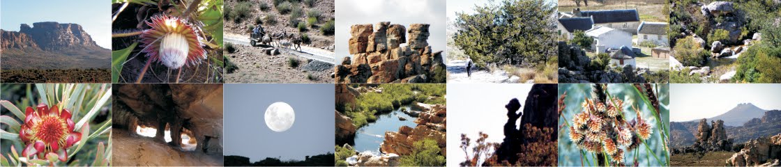
It’s worried me that we have this extraordinary set of 16000+ photographs, thanks to Matt Britton, but as long as they are buried on a hard drive they are of no use to anyone.

And so the plan is to produce a CD [or maybe a DVD, depending on space required] that contains the following:
* Tracks for the major hikes and day walks – probably 30 to 40 of these. These will be in kml format for Google Earth, and gpx format for use in GPS readers. I can’t possibly put them in all the different current GPS-file formats so you would have to download the free converter that suits you;
* a photo-string of 50 to 100 captioned, geo-tagged photos per hike, in kmz format, that can be loaded into Google Earth where they will appear as a string of ‘thumbnails’ along the relevant route; click on each mini-pic to open it up;
* and possibly a slide-show/movie that you can open in Picasa or Windows Media Player of the same photos, for the same hikes.
The CD will thus allow you not only to plan future trips to the Cederberg but also to glimpse the corners that you may not know. I’m sure that Galeo and others may not like the idea but, if you prefer self-discovery, you don’t have to buy the CD.
 An important aspect of Matt’s photos is that they were all taken in the same year [2011] in the same 5-month period [May to September]. They are thus a comprehensive and historic record of burnt and unburnt areas, the state of paths and, very importantly, the state of many of the surviving cedars. The info on the CD will thus become something of an historic record as well.
We have put together a couple of ‘teasers’ as movies on YouTube – these are shortened, 1 min 30 sec versions of the photo-strings proposed above. The music is mostly pretty awful, but we can only afford non-copyrighted freebies here so you may want to turn off the sound ...
Try them – just click on the name:
Heuningvlei Donkey Trail
Sas se Kloof [Kleinvlei to Wupperthal]
Zimri se Pad [Pakhuis to Boskloof]
Krakadouw [Heuningvlei to Groot Krakadouw Peak
and also
1600 Cape Flowers 1 and 1600 Cape Flowers 2 [each with 90 flowers]
... which means that the Corrections Blog will have to wait a little longer ....
Kaartman, 22 October 2013
It’s worried me that we have this extraordinary set of 16000+ photographs, thanks to Matt Britton, but as long as they are buried on a hard drive they are of no use to anyone.

And so the plan is to produce a CD [or maybe a DVD, depending on space required] that contains the following:
* Tracks for the major hikes and day walks – probably 30 to 40 of these. These will be in kml format for Google Earth, and gpx format for use in GPS readers. I can’t possibly put them in all the different current GPS-file formats so you would have to download the free converter that suits you;
* a photo-string of 50 to 100 captioned, geo-tagged photos per hike, in kmz format, that can be loaded into Google Earth where they will appear as a string of ‘thumbnails’ along the relevant route; click on each mini-pic to open it up;
* and possibly a slide-show/movie that you can open in Picasa or Windows Media Player of the same photos, for the same hikes.
The CD will thus allow you not only to plan future trips to the Cederberg but also to glimpse the corners that you may not know. I’m sure that Galeo and others may not like the idea but, if you prefer self-discovery, you don’t have to buy the CD.

We have put together a couple of ‘teasers’ as movies on YouTube – these are shortened, 1 min 30 sec versions of the photo-strings proposed above. The music is mostly pretty awful, but we can only afford non-copyrighted freebies here so you may want to turn off the sound ...
Try them – just click on the name:
Heuningvlei Donkey Trail
Sas se Kloof [Kleinvlei to Wupperthal]
Zimri se Pad [Pakhuis to Boskloof]
Krakadouw [Heuningvlei to Groot Krakadouw Peak
and also
1600 Cape Flowers 1 and 1600 Cape Flowers 2 [each with 90 flowers]
... which means that the Corrections Blog will have to wait a little longer ....
Kaartman, 22 October 2013
Subscribe to:
Posts (Atom)