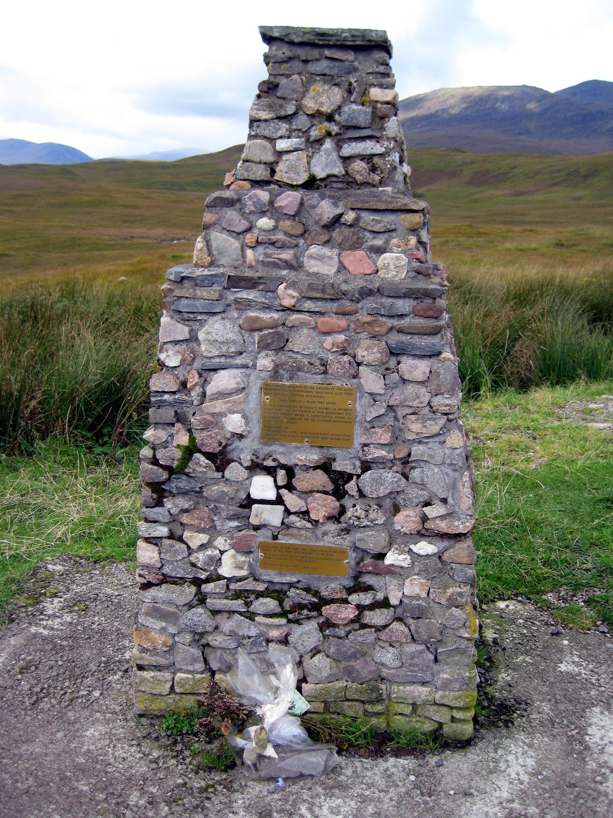
If you’re a mountaineer interested in Munros, have a look at blog #13 below.
Contents this month:
1. Places to Stay: maps of walks outside the Wilderness Area; Petrol at Dwarsrivier
2. A debate: accident sites, grave sites, memorials
3. A Cederberg survey beacon from 1819
4. Mapping progress
1. Places to Stay: maps of walks outside the Wilderness Area; Petrol at Dwarsrivier
First, Cisca Nieuwoudt has asked me to point out that soon petrol will no longer be available at Dwarsrivier; they are negotiating with Cederberg Oasis who might take over the supply. Watch this space.
Second, we welcome Bushmans Kloof, Kunje, Ouma’s House at Ysterplaat [near Kunje], De Pakhuys and Cederberg Oasis onto the map. Good info about hiking routes not inside the Wilderness has been received from these and others such as Jamaka and Nuwerus, and we’re looking forward to a really comprehensive map that includes all of these ‘private’ hikes.
 |
| Gerrit Karsten sent this track of the Visgat Trail at Cederberg Oasis. Contributions like this are really useful ... more, please! |
2. A debate: accident sites, grave sites, memorials
Arising from the Munro Memorial, subject of my previous blog, it’s a notable feature of the Scottish landscape that there are memorials all over the place. They might be quite modest, celebrating St Columba’s chapel constructed near the Mull of Kintyre in 563 AD [makes van Riebeeck look a little silly, hay] or absolutely over-the-top indulgences of dark and gloomy masonry [you can watch Paul McCartney singing about the Mull at http://www.youtube.com/watch?v=K5626WzsfMw ].
 |
| St Columba’s Chapel and more gloomy Scottish memorials – even a paley-loitering knight |
Our Cederberg map records many memorials – the settlement cemeteries, the Anglo-Boer War forts; the Englishman’s Grave, the unmarked graves at Papkuilsfontein – and the 1945 aircraft accident at Pakhuis. This was recently reported upon by Go! Magazine, controversially because there were inaccuracies in the report. CapeNature were not happy with the article, which incorrectly suggested that a trail was being built to the site – it is not! CN suggested that the crash location was a “grave site” and that souvenir hunters should be discouraged. I’d agree with that, but Graham Bellairs has also put his oar in ... so here’s a debate where you can throw your hat into the ring too, please ... http://www.slingsbymaps.com/contactus.aspx
“Interesting story about the Junkers. I think it should be left on the map. It is far from any path and on a remote steep mountain slope at 1000 metres so it’s unlikely to be visited by many and those with the desire to do so would probably be respectful. I mean, Louis Leipoldt’s grave is still there at the side of the pass and would be far more subject to possible vandalism or ‘souvenirism’ ...
“People die all over the show in all sorts of gory ways. The mess gets cleaned up, the wrecks of planes, cars and buses are removed, the roads are reopened for traffic and life goes on... The wreckage of the jets was removed from Devil’s Peak and the pristine beauty of the slopes restored. The runway was cleared and repaired and Charles de Gaulle was reopened after the spectacular Concorde crash in more recent times. Hiroshima has been rebuilt. I wonder why CapeNature or the SA Air Force have not cleaned up the mess left behind in the wilderness area near Pakhuis Pass? What makes it so special and different? [my bolding – Ed] I think it is misplaced sentiment. Clearing a crash site does not detract from the respect or sadness for the loss of the dead which fellow humans show and feel for those who died so tragically.
“It will be interesting to see what people have to say. I still think that marking the spot is fine as long as there is a note that visitors should respect the site ...”
 |
| Graham and friends on their way to climb Faith, Hope and Charity [Pakhuis] |
“A friend drew my attention to your response to the Weg/Go! magazine article on the Junkers crash in the Cederberg and I am responding to your request for the date of the crash. My uncle, Capt K. L. O’Leary (SAAF) died in that crash on 8 July 1945. I contacted the SAAF Museum to check whether there had been more than one Junkers crash in the Cederberg. I have pasted their reply below ...
“ ‘Dear Paddy, it was definitely 1945. Your uncle was unfortunate to be a passenger on the flight, the crew were Captain HP Blinkhorn AFC (pilot), Flt-Sgt RH Ford and Air-Cpl FE Ford (wireless operator). It was en-route Swartkop to Brooklyn (Ysterplaat) with a cargo of plywood when it crashed in heavy cloud and rain conditions. I understand there are still a few smaller pieces of the wreckage on site, the largest, a section of rear fuselage, was removed to the Air Force Museum at Swartkop in Pretoria a few years ago for display.’
“ ‘Regards Steven McLean, Historical Research Assistant to SAAF Museum, AFB Ysterplaat.’
“I’m delighted that information is useful to you. I was very pleased that you had noted and pointed out the inaccuracies in the Weg! article, not just the one I knew about. I ... feel that it would be good to have some kind of memorial on the site to the men who died in the crash.”
What do you think?
3. A Cederberg survey beacon from 1819
George van der Watt sent us this pic from Driehoek, of a ‘memorial’ of quite a different kind.

Thanks for the pic, George. The engraving on the rock is a surveyor’s mark – it reads “IBM D 4 Juny 1819”, which was the day upon which a surveyor, Jan Schutte, finished his survey of Driehoek – he had been ordered to survey all the Cederberg farms by a British Government commission of inspection. The D stands for Driehoek and the date is the survey date, but I haven’t a clue what IBM stands for. Any offers?
 |
| Johann Lanz sent this pic of another rock arch in the Klein-Beesgat area |
4. Mapping progress
After a month’s break exploring the Scottish Highlands and northern Wales we are back at the drawing board; the mapping of Side Two proceeds apace. No deadlines yet! In the meantime, we’ve had inputs on the Rim of Africa routes from Galeo Saintz and Johann Lanz, and lots of inputs on the Howes-Howell photos. We need more, though – keep ’em coming, please.
 |
| Trevor Rennison’s pic of Howes-Howell’s ‘Twin Blocks’, below Murraysberg |
Inputs already acknowledged [if I have left you out, please let me know!]:
Rudolf Andrag, Alex Basson, Graham Bellairs, Chris Berens, Willem Beukes, Hendrico Burger, Lizette Burger, Theresa Burton, Eleanore Colyn, Andrea and Moritz Connrad, Louis Conradie, David Donald, Connie & Lizzie du Toit, Laurence Elton, Kerneels Filander, Ferdi Fischer, Carina Hanekom, Theunis Hanekom, Peter Hart, Ronnie Hazell, Tony Heher, Sam Jack, Jeroen Kant, Gerrit Kartsen, Tony Kings, Isak Koopman, Thys Kruger, Paul la Grange, Patrick Lane, Johann Lanz, Justin Lawson, Margie le Roux, Nicky Lombard, Tony Lourens, Sandy MacDonald, Quinton Martins, Charles Merry, Eugene Moll, Wim Morris, Greg Moseley, Anneke Nieuwoudt, Cisca Nieuwoudt, Jannie and Katrin Nieuwoudt, Marianna Nieuwoudt, Pip Nieuwoudt, Barry Ockhuis, Joey Ockhuis, Kellie of Grasvlei, Caro & Steve Oldroyd, Paddy O’Leary, Mare Olivier, Linton Pope, Peter Jan Randewijk, Trevor Rennison, Galeo Saintz, Mike Scott, Mariet Smit, Haffie Strauss, Julyan Symons, Gert Theron, Edmund Thompson, Ingar Valentyn, Anne-Marie van der Merwe, Leonie van der Merwe, George van der Watt, Hennie van der Westhuizen, Johan van der Westhuizen, Charité van Rijswijck, Kosie Viljoen, Jill Wagner, Torben Wiborg, Ezan Wilson, Steven Windell and Louise Esterhuizen, Mary Anne Zimri
Kaartman, 15 October