Thursday, November 15, 2012

#15 November 2012 Report Back


In this blog:

1. 1:40 000 or 1:50 000? Some good news!

2. New places to stay, and more private hikes

3. Feedback: Memorials and Howes-Howell photos

4. Cederberg 100

___________________________________________

1. 1:40 000 or 1:50 000? Some good news!

Received a comment from ‘Stephen’ [no surname, no email – step forward please, Steve]:
‘I think the map looks really good but far too busy – cluttered with all sorts of information that you simply don’t need to see on the map ...’
Well, we had that debate some months ago and I have no intention of reviving it, but it has bothered me for some time that 1:50 000 is a very small scale for a hiking map. You won’t find many good hiking maps overseas at less than 1:25 000. The Cederberg area is too big for that scale – think about it, you’d need a map four times larger than the 1:50 000 sheets – or four double-sided sheets with eight maps. However, I have worked out a compromise and the samples are here for your inspection. Click on the sample and it should enlarge. I took the complex area around Heuningvlei/Krakadouw, which is difficult to show without Steve’s ‘clutter’ at 1:50 000, and tried it at 1:40 000.
The difference is significant and so we’ve decided to produce the final maps at 1:40 000. There will be two double-sided maps, approx A1 size each, and we will sell them together as a set, in one plastic pocket. We will absorb the extra cost on the first edition, ie the whole will retail for the same price that the single, 1:50 000 map would have gone for. And we’re still aiming at Easter 2013 ...
The Heuningvlei area at 1:50 000 [2cm = 1km]. The original scale.
[Click on the map to enlarge it]
The same area at 1:40 000 [2.5cm = 1km]. Much clearer?
[Click on the map to enlarge it]
Having two maps means two title pages for North and for South, and I will soon be running a competition for cover photos for each, so if you’d like to see your pic in thousands of grateful hikers’ hands please start sifting your collection!

2. New places to stay, and more private hikes

Welcoming on board Petersfield [John Ross] and De Pakhuys [Thys Kruger]; both have private trails on their farms, and have sent great maps for inclusion. Great maps also received from a variety of others, including Bushmans Kloof [Jill Wagner], Cederberg Oasis [Gerrit Karsten] and Jamaka [Jannie Nieuwoudt] and more ...
We recently visited Kunje and got some great info from a very hospitable Theunis Hanekom.

The following accommodation places have not responded; we might have their emails incorrect, so if you know them please steer them our way:
Laughenis (Agter-Pakhuis); Karukareb (Boskloof); Keurbos (near Algeria); Koedoeskop (off N7); Old Village Greys Pass (Piekenierskloof); Allandale (near Citrusdal); De Eike (near Citrusdal); Wolfkop (near Citrusdal).
We’ve no contact details for the following; do they still exists?
Klein-Kliphuis (Pakhuis Pass); Sawadee (Nieuwoudts Pass); Little Boy’s Farm [Klein Jongensfontein] (off Nieuwoudts Pass); Robyn (N7); Waterfall near Citrusdal; Berg en Dal (near Kunje).
Clockwise from top left: Vlerkboog on Arch Peak; Klein-Beesgat Arch; Spinnekop Arch; Sandfontein Arch. Pics by Andricus van der Westhuizen
3. Feedback: Memorials and Howes-Howell photos

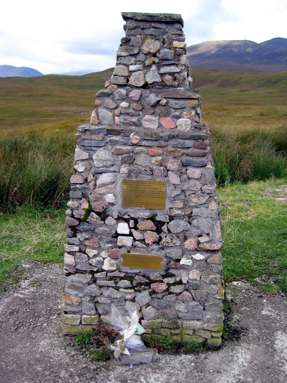
Mike Scott sent this sensible response to the Memorials issue:
‘Agree with you that the SAAF crash site should be marked  for the historical record as it is just like the Boer War battlefields or a shipwreck ... Whether to erect a tidy memorial in a ‘public’ place or not is often bedevilled by emotional views, but mine is that we do not want a proliferation of plaques, etc ... if there is a need, then gather them in one place at the Park entrance or somewhere suitable which is what is happening now in Scotland and elsewhere, like the pillar for memorials at the upper Cable station on TM.’

Mike also sent a valuable response to the Howes-Howell photos, and I have a ‘wrap’ of almost all the mystery arches from Andricus van der Westhuizen, with pics and coords – fantastic!!, and many thanks to you both. 
Mike van Wieringen sent this:
‘We stood on the same arch this past weekend as the arch on Arch Peak in the picture with the two standing on top of it [‘Vlerkboog’]. It is situated just below the escarpment looking across onto Bloukop in the Sandfontein Peak area. There is a lovely large cave some 50 m below it. The GPS coords of the cave are S 32° 36' 58.9"; E 19° 14' 50.5" to an accuracy of approx 50 m, so the arch should be within about 100 m of that.’
Does anyone have an email address for Mike van Wieringen? I would like to put him on our mailing list.
Sam Jack sent this pic by RA Hayes of Sterrebosbank. This is the shale band that wraps around the northern end of Sneeuberg and it used to carry a popular footpath that has long disappeared. The most popular ascent of the peak also used to start from here.
4. Cederberg 100

Peter Hart has sent me info about the new Cederberg 100 trail –
This is a seven day/eight night, 100km “slackpacking” trail running between the top of the Pakhuis Pass in the north to the Driehoek Resort in the central Cederberg. From the top of the Pakhuis Pass the route leads down via Amon se Vlak, Amon se Poort and Die Toring to Boskloof for the night. On the second day the route goes up Krakadouwpoort and over Krakadouw Pass to the Moravian village of Heuningvlei for the night. On the third day the route heads south via the Boontjieskloof Hut and Boontjieskloof to Brugkraal for the night. On the fourth day the route carries on south via Grasvlei, the spectacular waterfalls on the Grasvlei River and over Middelkopnek to Kleinvlei. The route on the fifth day makes a deviation up Dassieboskloof for views of Skerpioensberg and Sneeukop and then proceeds to Eselbank. On the sixth day the route goes over the mountain (weather permitting) to the little village of Langkloof, and on the last day the route goes over Gabriël’s Pass, with a deviation to the Wolfberg Arch, to Driehoek. There the group is met and conveyed back to Clanwilliam for the last night.
For more info see www.cedheroute.co.za
Torben Wiborg riding ‘The Slug’ on Groot Krakadouw
[Photo: Graham Bellairs]
Inputs already acknowledged [if I have left you out, please let me know!]: 
Rudolf Andrag, Alex Basson, Graham Bellairs, Chris Berens, Willem Beukes, Hendrico Burger, Lizette Burger, Theresa Burton, Eleanore Colyn, Andrea and Moritz Connrad, Louis Conradie, David Donald, Connie & Lizzie du Toit, Laurence Elton, Kerneels Filander, Ferdi Fischer, Carina Hanekom, Theunis Hanekom, Peter Hart, Ronnie Hazell, Tony Heher, Sam Jack, Jeroen Kant, Gerrit Kartsen, Tony Kings, Isak Koopman, Thys Kruger, Paul la Grange, Patrick Lane, Johann Lanz, John Ross, Justin Lawson, Margie le Roux, Nicky Lombard, Tony Lourens, Sandy MacDonald, Quinton Martins, Charles Merry, Eugene Moll, Wim Morris, Greg Moseley, Anneke Nieuwoudt, Cisca Nieuwoudt, Jannie and Katrin Nieuwoudt, Marianna Nieuwoudt, Pip Nieuwoudt, Barry Ockhuis, Joey Ockhuis, Kellie of Grasvlei, Caro & Steve Oldroyd, Paddy O’Leary, Mare Olivier, Linton Pope, Peter Jan Randewijk, Trevor Rennison, Galeo Saintz, Mike Scott, Mariet Smit, Haffie Strauss, Julyan Symons, Gert Theron, Edmund Thompson, Ingar Valentyn, Anne-Marie van der Merwe, Leonie van der Merwe, George van der Watt, Andricus van der Westhuizen, Hennie van der Westhuizen, Johan van der Westhuizen, Mike van Wieringen, Charité van Rijswijck, Kosie Viljoen, Jill Wagner, Torben Wiborg, Ezan Wilson, Steven Windell and Louise Esterhuizen, Mary Anne Zimri

–Kaartman, November 2012

Monday, October 15, 2012

#14 October report back


If you’re a mountaineer interested in Munros, have a look at blog #13 below.

Contents this month: 

1. Places to Stay: maps of walks outside the Wilderness Area; Petrol at Dwarsrivier

2. A debate: accident sites, grave sites, memorials

3. A Cederberg survey beacon from 1819

4. Mapping progress


1. Places to Stay: maps of walks outside the Wilderness Area; Petrol at Dwarsrivier

First, Cisca Nieuwoudt has asked me to point out that soon petrol will no longer be available at Dwarsrivier; they are negotiating with Cederberg Oasis who might take over the supply. Watch this space.

Second, we welcome Bushmans Kloof, Kunje, Ouma’s House at Ysterplaat [near Kunje], De Pakhuys and Cederberg Oasis onto the map. Good info about hiking routes not inside the Wilderness has been received from these and others such as Jamaka and Nuwerus, and we’re looking forward to a really comprehensive map that includes all of these ‘private’ hikes.
Gerrit Karsten sent this track of the Visgat Trail at Cederberg Oasis. Contributions like this are really useful ... more, please!

2. A debate: accident sites, grave sites, memorials

Arising from the Munro Memorial, subject of my previous blog, it’s a notable feature of the Scottish landscape that there are memorials all over the place. They might be quite modest, celebrating St Columba’s chapel constructed near the Mull of Kintyre in 563 AD [makes van Riebeeck look a little silly, hay] or absolutely over-the-top indulgences of dark and gloomy masonry [you can watch Paul McCartney singing about the Mull at http://www.youtube.com/watch?v=K5626WzsfMw ]. 
St Columba’s Chapel and more gloomy Scottish memorials – even a paley-loitering knight
I have no patience with edifices built by the taxpayer on behalf of fat-bummed politicians – yes, Britain has its Nkandla’s, too – but there are also countless memorials to very ordinary people. What these reflect is an essential, humane respect for people, for fellow human beings that our own oft-divided nation tends to lack, however much we may boast about ‘ubuntu’. 
Our Cederberg map records many memorials – the settlement cemeteries, the Anglo-Boer War forts; the Englishman’s Grave, the unmarked graves at Papkuilsfontein – and the 1945 aircraft accident at Pakhuis. This was recently reported upon by Go! Magazine, controversially  because there were inaccuracies in the report. CapeNature were not happy with the article, which incorrectly suggested that a trail was being built to the site – it is not! CN suggested that the crash location was a “grave site” and that souvenir hunters should be discouraged. I’d agree with that, but Graham Bellairs has also put his oar in ... so here’s a debate where you can throw your hat into the ring too, please ... http://www.slingsbymaps.com/contactus.aspx 
“Interesting story about the Junkers. I think it should be left on the map. It is far from any path and on a remote steep mountain slope at 1000 metres so it’s unlikely to be visited by many and those with the desire to do so would probably be respectful. I mean, Louis Leipoldt’s grave is still there at the side of the pass and would be far more subject to possible vandalism or ‘souvenirism’ ...
“People die all over the show in all sorts of gory ways. The mess gets cleaned up, the wrecks of planes, cars and buses are removed, the roads are reopened for traffic and life goes on... The wreckage of the jets was removed from Devil’s Peak and the pristine beauty of the slopes restored. The runway was cleared and repaired and Charles de Gaulle was reopened after the spectacular Concorde crash in more recent times. Hiroshima has been rebuilt. I wonder why CapeNature or the SA Air Force have not cleaned up the mess left behind in the wilderness area near Pakhuis Pass? What makes it so special and different? [my bolding – Ed] I think it is misplaced sentiment. Clearing a crash site does not detract from the respect or sadness for the loss of the dead which fellow humans show and feel for those who died so tragically. 
“It will be interesting to see what people have to say. I still think that marking the spot is fine as long as there is a note that visitors should respect the site ...”
Graham and friends on their way to climb Faith, Hope and Charity [Pakhuis]
What do the families of the crash victims think? This received from Paddy O’Leary ...
“A friend drew my attention to your response to the Weg/Go! magazine article on the Junkers crash in the Cederberg and I am responding to your request for the date of the crash. My uncle, Capt K. L. O’Leary (SAAF) died in that crash on 8 July 1945. I contacted the SAAF Museum to check whether there had been more than one Junkers crash in the Cederberg. I have pasted their reply below ...
“ ‘Dear Paddy, it was definitely 1945. Your uncle was unfortunate to be a passenger on the flight, the crew were Captain HP Blinkhorn AFC (pilot), Flt-Sgt RH Ford and Air-Cpl FE Ford (wireless operator). It was en-route Swartkop to Brooklyn (Ysterplaat) with a cargo of plywood when it crashed in heavy cloud and rain conditions. I understand there are still a few smaller pieces of the wreckage on site, the largest, a section of rear fuselage, was removed to the Air Force Museum at Swartkop in Pretoria a few years ago for display.’ 
“ ‘Regards Steven McLean, Historical Research Assistant to SAAF Museum, AFB Ysterplaat.’ 
“I’m delighted that information is useful to you. I was very pleased that you had noted and pointed out the inaccuracies in the Weg! article, not just the one I knew about. I ... feel that it would be good to have some kind of memorial on the site to the men who died in the crash.”

What do you think?

3. A Cederberg survey beacon from 1819

George van der Watt sent us this pic from Driehoek, of a ‘memorial’ of quite a different kind.

Thanks for the pic, George. The engraving on the rock is a surveyor’s mark – it reads “IBM  D  4 Juny 1819”, which was the day upon which a surveyor, Jan Schutte, finished his survey of Driehoek – he had been ordered to survey all the Cederberg farms by a British Government commission of inspection. The D stands for Driehoek and the date is the survey date, but I haven’t a clue what IBM stands for. Any offers?
Johann Lanz sent this pic of another rock arch in the Klein-Beesgat area

4. Mapping progress

After a month’s break exploring the Scottish Highlands and northern Wales we are back at the drawing board; the mapping of Side Two proceeds apace. No deadlines yet! In the meantime, we’ve had inputs on the Rim of Africa routes from Galeo Saintz and Johann Lanz, and lots of inputs on the Howes-Howell photos. We need more, though – keep ’em coming, please.
Trevor Rennison’s pic of Howes-Howell’s ‘Twin Blocks’, below Murraysberg

Inputs already acknowledged [if I have left you out, please let me know!]: 
Rudolf Andrag, Alex Basson, Graham Bellairs, Chris Berens, Willem Beukes, Hendrico Burger, Lizette Burger, Theresa Burton, Eleanore Colyn, Andrea and Moritz Connrad, Louis Conradie, David Donald, Connie & Lizzie du Toit, Laurence Elton, Kerneels Filander, Ferdi Fischer, Carina Hanekom, Theunis Hanekom, Peter Hart, Ronnie Hazell, Tony Heher, Sam Jack, Jeroen Kant, Gerrit Kartsen, Tony Kings, Isak Koopman, Thys Kruger, Paul la Grange, Patrick Lane, Johann Lanz, Justin Lawson, Margie le Roux, Nicky Lombard, Tony Lourens, Sandy MacDonald, Quinton Martins, Charles Merry, Eugene Moll, Wim Morris, Greg Moseley, Anneke Nieuwoudt, Cisca Nieuwoudt, Jannie and Katrin Nieuwoudt, Marianna Nieuwoudt, Pip Nieuwoudt, Barry Ockhuis, Joey Ockhuis, Kellie of Grasvlei, Caro & Steve Oldroyd, Paddy O’Leary, Mare Olivier, Linton Pope, Peter Jan Randewijk, Trevor Rennison, Galeo Saintz, Mike Scott, Mariet Smit, Haffie Strauss, Julyan Symons, Gert Theron, Edmund Thompson, Ingar Valentyn, Anne-Marie van der Merwe, Leonie van der Merwe, George van der Watt, Hennie van der Westhuizen, Johan van der Westhuizen, Charité van Rijswijck, Kosie Viljoen, Jill Wagner, Torben Wiborg, Ezan Wilson, Steven Windell and Louise Esterhuizen, Mary Anne Zimri

Kaartman, 15 October


Thursday, October 11, 2012

#13 Scotland


In January 2012 Torben Wiborg sent me this email:

“I have a 10-year goal to climb all the 1 600 metre named peaks in the ‘old’ Western Cape, as published in the MCSA Journal about 10 years ago.  There are 133 peaks on the list.  In  the past three years I have managed to climb 58 of them... interestingly enough, only 8 peaks on the list require rope work...”
I was reminded of Torben’s letter on our recent trip to the Scottish Highlands, where we came across this cairn on the little pass between the Bridge of Orchy and Glencoe.

I’m sure many MCSA members might be familiar with the cairn; but for the benefit of those who are not, the upper inscription reads:

This Cairn is dedicated to the memory of the many hundreds of mountaineers who have lost their lives climbing Scottish mountains.
They died in a place they loved.
Also in memory of Sir Hugh T. Munro of Lindertis, who prior to his death in 1919 published the “Munro Tables” after a meticulous study of locations and heights of all Scottish Mountains in excess of 3000 ft [914.4 metres].
Thereafter all mountain summits and associated peaks over 3000 ft became known as “Munros” and “Munro Tops” respectively.

The second inscription reads:

Each stone in this cairn was taken from peaks over 3000 ft by W.G.Park and number 795 in total. The headstone is from the ruins of Lindertis House, former home of Sir Hugh Munro.
Cairn built by W.G.Park – May 2000

The rugged Munros might be just a little more than half the height of Torben’s 1600 metre Cape peaks, but they’re at a latitude that would generally freeze the cotton socks off your average African. The memorial is poignant and, in its wild, wild setting at the edge of the Rannoch, Britain’s largest pure wilderness, evocative beyond measure. Do we have similar memorials to the brave souls who have conquered our own Munro’s? Good luck on the 133 “Torbens”, Torben!

– Kaartman, October 2012

Tuesday, August 21, 2012

#12: Know these places?


Any info that would help to locate these places photographed by Ken Howes-Howell between 1930 and 1960 would be very helpful; none of them are known to this mapmaker; most are in the MCSA property south of Kromrivier. Click on the pics to enlarge them; use http://www.slingsbymaps.com/contactus.aspx to respond, if you wish.

Four things first: thanks to George van der Watt we have some useful info about Panorama Cave. Second, enjoy this pic of Sneeukop, behind Eselbank, taken on the weekend just past [17 August 2012]. Third, Kunje have come on board and joined the accommodation places that will be on the map. Fourth, I’ll be away for the whole month of September so no more blogs or email replies from me until after October 5th ...

HOWES-HOWELL PICS ... 
What info I have is in the captions.


Howes-Howell calls this BUSHMAN’S CAVE; confirmed by many as WELBEDACHT CAVE
TWIN BLOCKS below Murraysberg; can you locate?
This formation is on ARCH PEAK; where is the peak?
This looks like the Camel, but H-Howell says it’s on
 TOTEM PEAK; ever heard that name?
This formation is called HINDENBURG and is near
Frustration Peak; can you locate it?
KLEIN-BEESGAT ARCH:  any info on where it is?
ARCH on Moorrees Peak; location??
ELANDSKLOOF WATERFALL; know it? [Not in Elandskloof, it's the waterfall on Waterfall Farm near Citrusdal]
ELANDSKLOOF POTHOLES: I presume they are close to the waterfall. Any info? [Not in Elandskloof, these are on Boontjiesrivier Farm near Citrysdal]

Inputs already acknowledged: Rudolf Andrag, Quinton Martins, Ronnie Hazell, Charles Merry, Ezan Wilson, Wim Morris, Alex Basson, Graham Bellairs, Julyan Symons, Galeo Saintz, Paul la Grange, Laurence Elton, Mike Scott, Peter Hart, Justin Lawson, Paul la Grange, David Donald, Johann Lanz, Cisca Nieuwoudt, Torben Wiborg, Sandy MacDonald, Trevor Rennison, Hendrico Burger, Nicky Lombard, Jeroen Kant, Patrick Lane, Ingar Valentyn, Pip Nieuwoudt, Eugene Moll, Greg Moseley, Tony Heher, Andrea and Moritz Connrad, Hennie van der Westhuizen, Isak Koopman, Kerneels Filander, Kellie of Grasvlei, Barry Ockhuis, Joey Ockhuis, Gert Theron, Mary Anne Zimri, Louis Conradie, Haffie Strauss, Charité van Rijswyck, Chris Berens, Willem Beukes, Kosie Viljoen, Jannie and Katrin Nieuwoudt, Tony Kings, Steven Windell and Louise Esterhuizen, Mare Olivier, Sam Jack, George van der Watt

Looking forward to hearing from you!
Kaartman, August 2012

Sunday, August 5, 2012

Report Back #11


Time to welcome on board some of the very fine accommodation establishments that ring the Cederberg; and a report back on general progress on the map. There are a couple of questions we need help to resolve too, please.


1. General mapping progress and future time scale


2. Welcoming places to stay on board


3. Know this place? Where’s this place? Rudolf, how about it?


1. General mapping progress


First, thanks for all the many inputs we’ve received on how to show distances and times. It seems most likely that we’ll go for the little panel with distance and approx. time – but a bit smaller than it is on the sample. Any new inputs on this are still welcome.
Second, I’ve had an absolutely great input from Chris Berens, who has produced a great height-shadow screen for Side One, and will do the same for Side Two in due course [see pic].
Chris’s ‘raw’ file [left], and with my
height-shading overlaid [right]
Third, I agreed with Charles Merry that we should not show “suggested routes” at all, eg routes up some peaks where there are no paths. We’re settling upon [a] routes that follow jeep tracks, [b] established paths, and [c] “ways to go” but only where these are old paths that have become faint and hard to find.
Fourth, we’ll be characterising the Cederberg Heritage and the Rim of Africa routes with these little symbols [I’m still waiting for that gps track, Galeo!]:—


Fifth, drawing of Side 2 is well underway. The Google Earth shots for most of this area are of truly lousy quality, but Bing Maps has recently put up a brand new high definition set for the entire Cederberg, right up to date too. There is one problem – some critical areas, eg Wolfberg, are under cloud, and Bing doesn’t have that useful “history” feature.
Sixth, Graham Bellairs has asked for a timescale on production of the map. It’s a tricky one, Graham, because you never know what future problems might arise. I had hoped for Christmas 2012 but I have to be overseas for a month in September which cuts out a slice of time. Realistically, we’ll be in print by Easter 2013, hopefully sooner.
Last, we got more great names from Willem Beukes of Traveller’s Rest [see below], and Kosie Viljoen of Eselbank.


2. Welcoming places to stay


When we produce touring maps we automatically include [at no charge] as many places to stay as possible. However, we decided with a hiking map of the Cederberg it would really only be appropriate to include places that cater for hikers. We emailed all those we know of who  are in the area to be covered by the map; we’ve had an excellent response. We’ll assume that those who don’t reply don’t want to be included ...
Thanks and welcomes are thus owing to:
Agter-Pakhuis: Alpha-Excelsior, Enjo Nature Farm, Traveller’s Rest, and all the Wupperthal buiteposte
Clanwilliam Boskloof: Boskloof Swemgat; Bovlei Guest Farm; Klein Boschkloof and Krakadouw
Olifants and Rondegat Valleys: Cederberg Cottage; Gecko Creek; Grootkloof; Jamaka; Rondegat; Ukholo Lodge
Agterberg: Bakkrans and Keurbosfontein; Cederberg Chalets [Zuurfontein]; Drie Hoek; Dwarsrivier; Kromrivier; Nuwerust
Piekenierskloof & Citrusdal: Boschkloof; Hebron; Rockwood


Special thanks for extra inputs go to Traveller’s Rest, where Willem Beukes showed us around and provided lots of lekker unrecorded names in the Agter-Pakhuis; Jannie and Katrin Nieuwoudt of Jamaka for first class info about their trails; Tony Kings for boundary info for the Cederberg Chalets area; Steven Windell and Louise Esterhuizen of Nuwerust [Cederberg Experience] for great trail info, and similar good trail stuff from Mare Olivier of Cederberg Cottage. Lindon Pope has also promised similar info for Gecko Creek in due course.


Lastly on this, we’ve been unable to find valid email addresses for the following: can anyone put us in contact with them?
Klein-Kliphuis; Sawadee; Little Boy’s Farm [Klein Jongensfontein]; Robyn; Petersfield; Waterfall Citrusdal; Kunje; Berg en Dal; Suikerbossie; Biedouw Farm; Biedouws Guest House; Mertenhof


3. Know this place? Where’s this place? Rudolf, how about it?


[a] On the path past Duiwelsgat, between the Uitkyk Pass and Sneeuberg hut, there is a point on the map named “Sederhoutstasie”. Like many names on the existing maps there is no precision about the location of this historic feature. So, my question: are these pics by Matt Britton photos of Sederhoutstasie? Or is it closer to Uitkyk?
Is this Sederhoutstasie? In the first pic it’s the rocky koppie
surmounted by cedar trees; the view is south towards Sneeukop,
 and Duiwelsgat is down on the right.
Two more views of the same koppie; is this Sederhoutstasie?
 Click on the pics for a larger view.


[b] Sam Jack is doing botanical research in the Cederberg and is trying to find locations for a wonderful set of photos from the 1930s by Ken Howes-Howell. These pics also include many forgotten names; the following is described by the photographer as being “Cedar tree – Dassieberg – Wüpperthal Kloof (1931)”. I assume [but could be wrong] that Dassieberg might be the same as Dassiesbos, the rugged tangle of boulders between Skerpioensberg and Kleinvlei, and that Wupperthal Kloof must be the same as the Sand River canyon that runs down the Vogelgesang Valley just south of the above. Any offers on a location for this pic?
Howes-Howell’s 1931 photo captioned
‘Cedar tree – Dassieberg – Wüpperthal Kloof’ – any offers?


Inputs already acknowledged: Rudolf Andrag, Quinton Martins, Ronnie Hazell, Charles Merry, Ezan Wilson, Wim Morris, Alex Basson, Graham Bellairs, Julyan Symons, Galeo Saintz, Paul la Grange, Laurence Elton, Mike Scott, Peter Hart, Justin Lawson, Paul la Grange, David Donald, Johann Lanz, Cisca Nieuwoudt, Torben Wiborg, Sandy MacDonald, Trevor Rennison, Hendrico Burger, Nicky Lombard, Jeroen Kant, Patrick Lane, Ingar Valentyn, Pip Nieuwoudt, Eugene Moll, Greg Moseley, Tony Heher, Andrea and Moritz Connrad, Hennie van der Westhuizen, Isak Koopman, Kerneels Filander, Kellie of Grasvlei, Barry Ockhuis, Joey Ockhuis, Gert Theron, Mary Anne Zimri, Louis Conradie, Haffie Strauss, Charité van Rijswyck, Chris Berens, Willem Beukes, Kosie Viljoen, Jannie and Katrin Nieuwoudt, Tony Kings, Steven Windell and Louise Esterhuizen, Mare Olivier, Sam Jack


Thanks for keeping up with me!
Kaartman, August 2012

Tuesday, July 3, 2012

#10: Second Sample Map

SEE BELOW FOR NEW MAP SHOWING DIFFERENT WAYS OF INDICATING DISTANCES


This second sample “bit of map” shows some Cederberg high country, and the proposed mapping style for the high peaks above the shale band.  It’s ready and awaiting your critical inputs, and for that reason I have included a couple of features that some might rather not see included. If you feel that way, please tell. I’m not wedded to any specific info that might appear off the established paths. The “Cederberggrot” is in the wrong place and if I don’t get any further info I will leave it out. “Laurie se Hel should move down a bit, more or less in line with “Eselbank”.


Some explanations:


The map-sample is a condensed jpg file, so do not expect all the linework and lettering to be as sharp as the final printed product [black lines might appear a hazy grey, for example];
colours may not be 100% true, depending upon your monitor settings;
the original is approx. 1:50 000 scale. To reproduce this you need to print or view the map-sample at max. width of 200 mm;
there is no key to the sample [there will be one, of course, on the complete map] so there may be some new symbols that are unfamiliar.  Green dots on yellow are the standard paths within the Wilderness; green dashes are ditto jeep-tracks. Broken brown, green or red dotted lines on pale yellow are various classes of “ways to go”, where there may not be an actual path. If there is anything else you don’t understand please contact me via http://www.slingsbymaps.com/contactus.aspx or my email if you have it.
A name in red means we have not located it accurately yet;
there is only a long/lat grid on the map at this stage; there are requests for a UTM grid as well but I’m still working on how to do this without crowding the map too much.


Please send all and any comments to me via the web address above [or my email if you have it]; the map will remain online UNTIL 31 JULY 2012 ONLY, so this is your chance to have your ideas considered and maybe incorporated, too! Just remember, please, that like the first sample this is a tiny fraction of Side One of the map, which will be A1 in size when printed.


I will shortly be publishing another sample piece, this time to show two different ways of indicating distances on the map, for your comment.
You can also simply click on this image to enlarge it
View and/or download the new map-sample from
http://www.slingsbymaps.com/images/sample-cederberg2.jpg 


Two ways of showing distances; 
PLEASE comment on which method you prefer.
1. Purple arrow: a small panel that shows distance between path junctions and an approximate time [cf our Silvermine map], or
2. Red arrow: distance to the next junction shown in small red numbers at the intersection; no times shown [cf our old Drakensberg series]. Times are difficult to show with any accuracy, especially for uphill/downhill, etc etc.

Click on the map to enlarge it
Explanations of Some Names:
Vuilpoortjie from the nek below Tafelberg – a daunting sight for a 6-year old who has just climbed up from Welbedacht!
Some of the names on this sample have interesting stories. “Vuilpoortjie” east of Shadow Peak is the route that was used by school children from Eikeboom, Driehoek, Welbedacht, etc. on their way to weekly-boarding school at Eselbank [the Dwarsrivier/Kromrivier kids used Gabriël’s Pass]. Welbedacht Cave and the now largely-unused Cederberggrot were the only significant shelters along the route. 
Vuilpoortjie [about 1690m] from the shaleband on the Eselbank side. Fancy trying that on a Friday afternoon in February?
Next time you’re toiling up a long uphill slog somewhere in the mountains think of those kids, aged 6 to perhaps 13 ... every Friday afternoon and every Sunday morning they walked that route, forty school weeks a year for six or seven years.
Lucky contemporary boarders at Eselbank – they [sometimes] get fetched and carried by bakkie or donkey-cart ...
Eselbank is a name with a variety of suggested origins. The most common seems to be that somewhere there is a trough-shaped rock that was used to hold the donkeys’ feed. Strangely enough, no one knows where that trough is any more. I prefer the origin offered by Alex Basson, as told to him by the Eselbankers themselves, and so probably true. “Bank” can also mean “ledge” or “overhang” [in the Baviaanskloof “bank” has become “bak”]. 
Eselbank cottage
One day an elderly woodcutter went with his donkeys to collect cedar wood in the rocky jungle known as Laurie’s Hell [or Laurie se Hel – the Lauries are an old Eselbank family]. While sawing timber a heavy tree fell the wrong way and broke the old man’s leg. In great pain he managed to drag himself under an overhang, but was then unable to move any further. No one knew exactly where he was, and his chances of being found in that maze of boulders were zero. But his oldest donkey, a faithful old beast that had been with him for many years, found him there. The donkey set up a braying and a neighing such as only a donkey can, and kept this up all afternoon, all night and into the next day. Alerted by the ceaseless hee-haws the old man’s neighbours sent out a  search party, and brought him home to safety. The tiny cluster of houses became known as “De Eselbank” or “Eselbank” as a result.
Eselbank, with Laurie se Hel behind; Tafelberg peeping out, top left.


Inputs already acknowledged: Rudolf Andrag, Quinton Martins, Ronnie Hazell, Charles Merry, Ezan Wilson, Wim Morris, Alex Basson, Graham Bellairs, Julyan Symons, Galeo Saintz, Paul la Grange, Laurence Elton, Mike Scott, Peter Hart, Justin Lawson, Paul la Grange, David Donald, Johann Lanz, Cisca Nieuwoudt, Torben Wiborg, Sandy MacDonald, Trevor Rennison, Hendrico Burger, Nicky Lombard, Jeroen Kant, Patrick Lane, Ingar Valentyn, Pip Nieuwoudt, Eugene Moll, Greg Moseley, Tony Heher, Andrea and Moritz Connrad, Hennie van der Westhuizen, Isak Koopman, Kerneels Filander, Kellie of Grasvlei, Barry Ockhuis, Joey Ockhuis, Gert Theron, Mary Anne Zimri, Louis Conradie, Haffie Strauss


Let the comments come rolling in ... don’t be shy.
Kaartman, 3 July 2012

Tuesday, June 19, 2012

#9: First Sample Map


Here it is at last: our first sample “bit of map”, ready and awaiting your critical inputs. Before I tell you how to find it, though, some explanations:

  • The map-sample is a condensed jpg file, so do not expect all the line-work and lettering to be as sharp as the final printed product;
  • colours may not be 100% true, depending upon your monitor settings;
  • the original is approx. 1:50 000 scale. To reproduce this you need to print or view the map-sample at max. width of 200 mm;
  • there is no key to the sample [there will be one, of course, on the complete map] so there may be some new symbols that are unfamiliar. Two purple cellphones with arrows pointing to each other indication reception over a path section, whereas a white cellphone means reception at that point only [if you’re lucky]. An upside-down yellow arrow means a bouldering site; a brown dotted line is a path used by boulderers; paths with CapeNature’s area are green dots, others are red. There are grades of path but only the standard “clear path” grade appears on the sample. If there is anything else you don’t understand please contact me at http://www.slingsbymaps.com/contactus.aspx 
  • A name in red means we have not located it accurately yet;
  • there is only a long/lat grid on the map at this stage; there are requests for a UTM grid as well but I’m still working on how to do this without crowding the map too much;
  • there are already two necessary corrections to the map – see below.

See link below to view or download the full-size version of the above
Please send all and any comments to me at the web address above; the map will remain online UNTIL 31 JULY 2012 ONLY, so this is your chance to have your ideas considered and maybe incorporated, too! Just remember, please, that is is a tiny fraction of Side One of the map, which will be A1 in size when printed.
    Below are some pics and comments about the two day walks in the Kliphuis/Pakhuis area that appear on the map-sample, plus a bit more input on that controversial Kruisrivier “path”.  
    We will also publish a sample bit of a high mountain area a bit later – watch out for it.
 View and/or download the map-sample from


The Pakhuisberg day walk starts from the Kliphuis campsite and climbs into the Pakhuisberg north of the Pakhuis Pass. It’s an easy walk over about 13.5 km of wild, infrequently-visited territory with great views, especially on the descent [I’m walking the circuit anti-clockwise]. 
Clockwise from Top Left:
1. The start of the path near the tar road is not clear; look out for the tiny cairn, centre foreground.
. The view down to Kliphuis campsite – now re-opened.
3. Rocky landscapes over the top.
4. A Heeria [Kliphout] and weathered rocks.
Don’t rely upon perennial water, but there are some strong streams after winter. There is one cave-shelter on the path that could shelter two or maybe three people, but it’s not really an overnighting spot.
Clockwise from Top Left:
1. That nervous moment when you realise that the leopard tracks are ON TOP of the boot-print you left there just minutes earlier ...
2. View back to Charity Peak, across the rocks
3. A welcome, but non-perennial, pool
4. Shelter for two, may be three, next to the path
There are great flowers, the fascinating rocks that the Cederberg is famous for, and plenty of wildlife, even frequent leopard-sign. 
Left to Right: A Phylica; an Erica; Leucospermum calligerum. Any offers on the names for the phylica and erica?
You must have a permit from CapeNature to enter the area; it’s part of the proclaimed Wilderness.
Clockwise from Top Left:
1. ‘Secret’ Falls; the waterfall is behind the rockface. This fall on the Kliphuis River is not shown on the sample-map: first correction necessary!
2. On the way back to Kliphuis: gravelly path
3. Dreadful spiny
Aspalathus near Kliphuis; name?? [Pardon the raindrops on the lens]
4. Scree below the Kliphuis Ridge
The Rocklands day walk also starts at Kliphuis, but I’d recommend a clockwise-direction. It’s also a comfortable 13.5 km but you could take a short cut and cut out 3.5 km from your day, thus missing some interesting country. The path ascends the Rheboksvallei parallel to the tarred road, not too much of a problem as there is seldom much traffic. 
Clockwise from Top Left:
1. Klipboom
[Heeria] copse near the Pakhuis Pass summit
2. The Amon se Pad footpath turn-off from the Heuningvlei Road
3. Kruidjie-roer-my-nie
[Melianthus major], a herb used to treat snake-bite and septic wounds; the sap is black and smelly
4. A rocky gargoyle
Near the summit of the pass there is an interesting Kliphoutboom copse, and you briefly join the Noodpad, the “donkey-cart” road to Heuningvlei, before swinging west on Amon se Pad. The route follows the old wagon road over the Pakhuis that predates the modern pass, first built by Bain in 1867. It passes several popular bouldering sites before reaching Duiwel se Kruis, the cross-roads where the Boskloof path descends Amon se Poort to the left. A few hundred metres down the path to the right is a rock-shelter that could sleep up to three adults. It’s on the right of the path, not the left as the sample shows [the second correction!].
Clockwise from Top Left:
1. Fine waboom trees on the path
2. A typical Rocklands chockstone or window

3. Rough repairs to the old wagon-track
 

4. The Gate, the false non-entrance to Amon se Poort
Thereafter the old road – there are several signs of old stonework and repairs – plunges deep into the Rocklands world of outcrops, pillars, cavelets, rock windows, etc etc. It’s all a bit dry, unfortunately, with no reliable perennial water, but the flora is great, especially the many herbs. As you near the Pakhuis Pass you pass through the area where C. Louis Leipoldt and Dr Pieter Le Fras Nortier first successfully cultivated rooibos tea.
Left: Ancient rooibos tea bushes
Right: Pyramid Rock
The path plunges down onto the main road where a cutting has left it dangerous and slippery – repairs needed here, CapeNature, please – and the only way home is a 1km stroll down the tarred road, past Leipoldt’s Grave, to Kliphuis. There’s very little traffic and a high probability of baboons, so the main road walk is not too bad.


Inputs


Not much info has come in since our successful name-gathering in the Wupperthal buiteposte, but we did get this letter from Louis Conradie – with more about that problematic Kruisrivier valley. I’m really unsure about how to deal with this on the map; any ideas, anyone?
I’m sorry I cannot reply to Louis – my system consistently rejects his email address, so please pass this on to him, those of you who know him. He writes [shortened]:
I led a group of 4 hikers on a 7 day CUM Hike-“expedition” doing a big circle starting from Algeria on 5 Sept. 2011 and finishing there again on 11 Sept. 2011.  Only 3 of us finished the whole route as one lady pulled out during day 5 due to feet problems.  The other two hikers who finished the route with me were David Rossouw and his wife, Karen, two very tough hikers, I must say!
On 10 Sept. 2011 we started from the Maltese Cross (where we slept the night of 9 Sept.), following the path to Bakleikraal and down into the valley of the Hekserivier past Riempie se Gat and Dons se Werf.  We lost the path quite a few times, but kept direction as I had already hiked that route in 2008.  On that hike in 2008 we wanted to take the path at the Kruisrivier which crossed over to Algeria, but somehow missed it and finished in the Pakhuispas [Nieuwoudt’s? - Ed] many kms later.
We could not reach the Kruisrivier before dark on 10 Sept. 2011, but on 11 Sept. easily found a path going upstream along the Kruisrivier, which was very motivating.  But not for long!  We soon experienced the same overgrown and almost impassable route as was already reported in your reports – in fact, there was no route at all.  But we wanted to take that route to Algeria, so we struggled upwards in the kloof to the top, doing less than 1 km an hour!  It was really bundu-bashing as I have not experienced at any time in my hiking career
When we arrived at the top of the Kruisrivier after our hectic struggle to get through and over everything, it was really a nice and easy hike down to Algeria.
  I intend doing a 9 day hike in the Cederberg this year again, from 8-16 Sept., and am thinking of including the Hekserivier valley in the hike once again.  Maybe CapeNature, especially Patrick Lane at Algeria, has sent out teams to clear that Kruisrivier path making it hikeable again.  If not, our guts will again be tested to the limit!


Already acknowledged: Rudolf Andrag, Quinton Martins, Ronnie Hazell, Charles Merry, Ezan Wilson, Wim Morris, Alex Basson, Graham Bellairs, Julyan Symons, Galeo Saintz, Paul la Grange, Laurence Elton, Mike Scott, Peter Hart, Justin Lawson, Paul la Grange, David Donald, Johann Lanz, Cisca Nieuwoudt, Torben Wiborg, Sandy MacDonald, Trevor Rennison, Hendrico Burger, Nicky Lombard, Jeroen Kant, Patrick Lane, Ingar Valentyn, Pip Nieuwoudt, Eugene Moll, Greg Moseley, Tony Heher, Andrea and Moritz Connrad, Hennie van der Westhuizen, Isak Koopman, Kerneels Filander, Kellie of Grasvlei, Barry Ockhuis, Joey Ockhuis, Gert Theron, Mary Anne Zimri, Louis Conradie, Haffie Strauss


Let the comments come rolling in, asseblief ...
Kaartman, 19 June 2012