Monday, December 12, 2011

Third Report-back


This will be my last report-back until after the holidays – so compliments of the Season to you all!


First, two older ‘responses’ that fell through the cracks because they came in long before we put up the Cederberg Hiking Map webpage. At Cisca Nieuwoudt’s request Hendrico Burger has sent in comprehensive GPS tracks for the MTB routes – old and new – at Dwarsrivier. Many thanks, Hendrico – these will certainly be on the final map, and also on the Dwarsrivier/Sanddrif downloadable freebie, when we get around to revising that!


Back in August Johann Lanz sent us the Panorama Cave coords and some useful path info.


Cathedral Rocks, also known as the Organ Pipes


Back to the present. Mike Scott has been sifting our virtual Book 3 and came up with these:


Picture 112 is just known as the Welbedacht cliff with rock climber’s routes mainly by Andrew de Klerk.
Picture 114 is the old Sleeppad used for sledges laden with Ceder logs.
[That’s what we thought, Mike, until Alex Basson put us right – see previous blog!]
Picture 118 is the Uilsgat needles, and Picture 120 looks suspiciously like another view of the Westernmost one.
Picture 127 does NOT look like The Anvil to me, unless there is another rock also called an anvil? [See NOTE below]
Picture 128 [Vogelgesangvallei] I am trying to find my pictures of the valley, but would tend to believe Ralph Taylor, as often Trig maps were wrong, and if not actually wrong, used names from the locals which differed from the ones used by mountaineers! 


Vogelgesangvallei:  we too agree with Ralph Taylor


Picture 129, mystery concrete-lined hole near Sneeukop Hut:  we thought it was an old toilet hole filled in when we were last there!
Picture 135 Yes - Cathedral Rocks, but some people refer to them as the Organ Pipes.
Picture 143 Yes [Boskloof Pinnacle]
Picture 144 Yes [the Machine Gun of Machine Gun Ridge].


Boskloof Pinnacle


Many thanks, Mike – looking forward to your inputs for Book 4. 


However, we’re still uneasy about The Anvil. Can anyone comment? 


We seem to have these options:


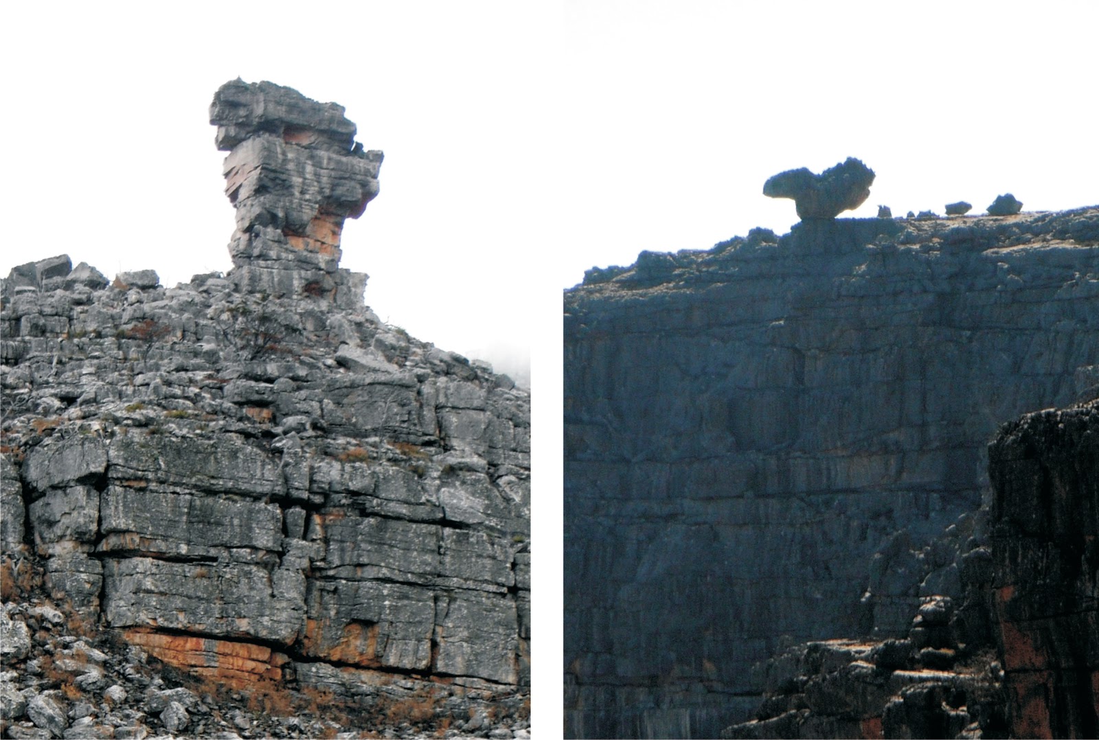
The Anvil – the left or the right?


David Donald sent this interesting account of the Maltese Cross path in the snow, thereby illustrating yet another hazard for the mapmaker: what happens when the path is simply buried? Unfortunately not all the high-altitude paths have tall beacons ...


David’s pic of the Cross
in the snow : we used it
on the cover of our second
Cederberg touring map
In the winter of 2001 or thereabouts, I set out to climb up to the Maltese Cross with two good friends, Peter Fiske and Chris Wren-Sargent.  It was a beautiful, clear day after heavy falls of snow across the Cederberg the previous night. However, as we made our way up the gully to the Cross, the path became more and more difficult to follow as the snow became thicker towards the top. Nevertheless, we floundered on through ever-thicker drifts but with a clear sight of the top of the gully to guide us. The sight which greeted us as we reached the plateau was absolutely stunning: a thick, white blanket of white as far as we could see with clumps of snow clinging to the ledges of the Cross itself. After having a mild snow-fight and taking some photos we retreated as rapidly as we could in the face of an advancing south-westerly squall of snow. When we showed the photos to the manager of the Nieuwoudt farm below, he was amazed: he had never before seen the Cross and its surrounds as deep in snow as that.


The moral of the story is simply that if any one contemplates climbing up that gully to the Maltese Cross when it has snowed, please be well clad, aware of what I have described regarding the path and, even on a day that starts out sunny and clear, keep an eye out for the sudden changes that the south-westerlies can bring!


Galeo Saintz sent a GPS track of the routes used by Rim of Africa - useful, Galeo. See what he's all about at www.rimofafrica.co.za


Justin Lawson continues to keep us prominent on the www.climb.co.za website: many thanks, Justin. I’m hoping some of your members spend some holiday time in the Cederberg, and send in info early next year!


Paul la Grange turned out to be a former colleague of Alex Basson, when the latter was teaching at SACS; Paul sent this snippet:


On one occasion, Alex, having had quite enough of the stresses of teaching naughty youngsters, took himself off to his favourite area near Basson’s Klip and by his own admission tried to live like a Bushman for a couple of days. He wore only a loincloth, no shoes and survived by living off the land. I cannot remember the details of the story, but suffice it to say that he did not last too long and had to scramble for his bundle of tucked-away clothes and emergency rations in quite a hurry! He did mention that the experience had done him the world of good and he certainly went on teaching for many years to come after that. 


And to end off, the formal stuff ...


Mapping: have digitised comprehensive map info from the northern edge down to a line more or less from Boskloof to Biedouw ... hope to be down to Wuppertal by New Year.
Response to webpage: 671 individuals since Nov 14; 102 Algeria maps, 150 books and 55 GoogleEarth photo-tracks downloaded.
Info already in:
Already acknowledged: Rudolf Andrag, Quinton Martins, Ronnie Hazell, Charles Merry, Wim Morris, Alex Basson, Graham Bellairs, Julyan Symons, Galeo Saintz, Paul la Grange, Laurence Elton, Mike Scott, Peter Hart

Friday, December 2, 2011

Second Report-back


Here are this week’s NEW INPUTS ... in the order received:


Strydom’s Path
First, a Fabulous Fax from Alex Basson, a genuine Cederberg old-timer who has been stomping the ’berg since he was twelve .... which was in 1943! Alex has info about names, places, stories etc etc that will all be available for the new map. I asked him about the ‘built path’ up Uilsgat – he tells me it was built as a pure folly by a long-gone forester, possibly a Mr Strydom, whom Alex described as a ‘frustrated road builder’. I will call that path ‘Strydom’s Path’ on the map, unless a different name comes to light. ‘Strydom’ also rebuilt the Eikeboom-Sneeuberg jeep track and the Pakhuis-Heuningvlei road that is still in regular use by donkey-carts, hikers and boulderers. Basson se Klip is named after Alex – see photo below.


The Pup – pic by Graham Bellairs
Graham Bellairs sent some valuable info about the path confusion around The Pup. Thanks, Graham, we had already found that the path on the south side of The Pup no longer exists. 
Graham also had more info about the old path up Protea Peak that Rudolf had mentioned to us. After a careful study of GoogleEarth and Bing maps I’ve managed to locate most of it – we’ll probably show it as a ‘way to go’ rather than a marked path.
Graham also suggested that we should not neglect the Klipbokkop and other paths in the Nuwerust area; we’ll certainly show all the routes that fall on the map, but we’ll need some GPS tracks.


Julyan Symons confirmed the pic of Welbedacht Cave, but still no names for the nearby rock-pillars – for some good news see below, Julyan.


Galeo Saintz asked that we include a link for the Rim of Africa trail – see www.rimofafrica.co.za 


Meidegat Falls near Sevilla
Paul la Grange named the falls at Riempie se Gat as Riempie’s Falls; he also pointed out that the Eselbank Falls are higher and even more impressive [how do these compare with the Meidegat Falls near Sevilla, by the way?]. 


Laurence Elton wrote about his recent [November] trip down the Heks River valley. Just as we did, his party found the Kruisrivier kloof path over to Algeria impassably blocked by fallen trees. His party bailed out to Klein-Jongenskraal and copied us their letter of complaint to CapeNature about the state of a path that is shown so prominently on their map. 
Hmmm. I can see the mapmaker’s biggest hazard rearing its ugly head here – ground features that change and render the map info incorrect ...
Laurence also asked for the inclusion of a UTM grid ... more on this later. He asked for True North to be at the top of the map: it will be.

Basson se Klip? Maybe. Pic by Mike Scott.
Mike Scott sent a couple of great photos and valuable info. He confirmed our pics of The Anvil, the correct position for Vogelgesang-vallei [Ralph Taylor was right, of course], and the Knobless Robot. Mike’s pic of Basson se Klip is included here, though I’ll have to get Alex Basson’s confirmation that this really is his klip! Mike confirmed the location of several other features, sent me off to revise my ‘Vanzylsklip’ with a new pic of the real thing, and he named one of your ‘unnamed pinnacles’, Julyan Symons – the one to the east of the Welbedacht path is the ‘Pepper Pot’ and was first climbed in 1969. [our pic 75]
Pepper Pot: climbed in 1969


Finally, Peter Hart of the Cederberg Heritage Route provided a couple of gps tracks for the Route’s great new 4-day trail from Driehoek to Wupperthal, via GabriĆ«l’s Pass and Eselbank/ Kleinvlei [opening January 2012]. Peter was great source of info, with several new names and some great – and previously unknown to us – waterfalls.
See www.cedheroute.co.za 


And, to end, the Formal Stuff ...


Mapping: completed geo-referencing & correct setting for the northern section; adding info about bouldering in the Pakhuis area.
Response to webpage: 413 individuals visited the website-page since 14 November. 82 Algeria maps, 112 books and 47 GoogleEarth photo-tracks were downloaded.
Links on other websites: These orgs kindly notified their members of our quest, though their websites:
Meridian Hiking Club  – http://www.meridian.org.za/news.htm 
Climb ZA – http://www.climb.co.za/2011/11/new-cederberg-hiking-map-can-you-help/ 
as well as the MCSA – http://mcsa.briefyourmarket.com/Newsletters/Mountain-Ears-December-2011/Help-make-a-new-Cederberg-hiking-map-.aspx 
Info already in: 
Already acknowledged: Rudolf Andrag, Quinton Martins, Ronnie Hazell, Charles Merry, Wim Morris.


Keep ’em coming!
Kaartman 2011-12-02

Monday, November 21, 2011

First Report-Back


To keep contributors up to speed on theirs and others contributions, as well as progress on the map itself I’ll put up a blog from time to time – so here is report-back #1.


Mapping has begun, working from north to south: the extreme northern end includes some of the Agter-Pakhuis as far as Wolfdrif at Travellers’ Rest. Base-mapping for that and the western part down as far as Boskloof is complete.
I’m hoping that we’ll have space for some inset-maps that will show some of the less-obvious “trail heads” at a bigger scale, eg Heuningvlei, and we might be able to fit these in instead of some of the extensive rooibos tea fields north of the Engelsman se Graf. If we can’t fit them in we’ll put them up as downloadable freebies.


Response to news of our web-page: after only one week, the cederberg-hiking page has had 167 unique visitors. 36 people have downloaded the map of Algeria and 42 have downloaded the various ‘books’. Several hiking clubs and branches of the MCSA have passed on our appeal for info to their members.
Not many people have visited this blog!
Anyone know the story behind these old 20c pieces left
on a rock in the Breekkrans Valley?


Info that has come in [in order of arrival]:


Rudolf Andrag provided a three-page list of problems with the existing maps, plus several great bits of info re Kromrivier and the Breekkrans Valley.


Quinton Martins suggested that the ‘built path’ up the Uilsgat valley was a wagon-road that has become partly collapsed. However, it’s not really wide enough even for a donkey cart – could this have been a logging track, using narrow, two-wheeled ‘dollies’ to hold felled cedars, the whole then towed down the mountain by mules? Quinton says he prefers the dolly he already shares his life with, but that’s a different story. If you fancy a job as a leopard-catcher/feeder/fondler/attendant or whatever, there’s a new post up for grabs at the Cape Leopard Trust, by the way.


Ronnie Hazell sent info and a Google earth image of the old leopard trap near Driehoek.


Charles Merry sent this very useful stuff:
Sederhoutkop Cave
Photos 69 and 70 are of Sederhoutkop, and the shelter is known as Sederhoutkop cave; it has a smaller cave above it;
72 is indeed Welbedacht Cave – this is also confirmed by Wim Morris;
73 – Charles confirms the position of Panorama Cave. At last it will be in the right place on a map!
135 is indeed a pic of Cathedral Rocks
153 is the spring at Bakmakersfontein – the coords we gave in Book 4 are a bit out, thanks to the GPS camera playing up that morning [apologies!]
181 – the ‘extensive beacon’ is in fact an old leopard trap.
186 – is indeeed a pic of Disa Pool.


Wim Morris responded:
Photo #50, the rock-pillar in the widest Wolfberg Crack, is known to rockclimbers as ‘The Knobless Robot’
51: this square-shaped ravine-head is the ‘venster’ of Vensterberg
Wim also sent the correct positions of Asjas se Kloof and Asjas se Grot, the latter not in Asjas se Kloof. Wim, do you know who Asjas was?


Keep your comments coming!


Kaartman 2011-11-20


Saturday, November 12, 2011

Opening the Dialogue ...


We’ve set up this special Cederberg Hiking Map blog as a sort of forum, where you can share and compare your comments and Cederberg-map ideas with us.


We’re hoping to collect as many of your answers as possible to the questions that we’ve asked in the four ‘books’ on the website – www.slingsbymaps.com/cederberg-hiking.aspx – but there’s more to it than that.


Your knowledge and experience of the Cederberg is probably more extensive than ours. You know the existing maps; you’ve got good ideas about what should be included in a new map - and maybe what should be left out. If you’d like to comment publicly feel free to leave your comments on this site. If you prefer to keep your comments private, please use the ‘Contact’ button on the website [www.slingsbymaps.com].


From time to time we’ll also describe a Cederberg hike on this site. We’d value your comments and responses to our accounts and would love to hear about your own experiences of these hikes.


When the map is in print we intend keeping this site open – for your ideas, reviews, or anything else; we really do want your inputs to make this ‘Hike the Cederberg’ map a worthy instrument for the enjoyment – and preservation – of these extraordinary mountains.


Welcome on board.


Kaartman, November 2011